
It does.
But... I haven't been flying much this year and the monthly subscription went up from $30/month to $37/month, probably to subsidize the enormous salary of the excrable Howard Stern. Yes, I Sirius-ly dislike him. And thank you to the three people that got that pun.
Without the long trips, about the only use I was getting from the fancy weather display was to show people that I was giving a ride to the amazing capability of being able to see inclement weather five states away. Impressive? Yes. Worth the cost of dinner at Red Lobster? Questionably. As recently as this morning I was debating just having my account inactivated until I start flying places again. I decided that I'd decide later, when I was back from my planned trip out to the farm and had ruminated (Again? I'm ruminating again??) on it for a few hours.
I'm back, and I think I'll keep it.
I wanted to go out to the farm to deliver my brother's GoPro video camera. He's been mounting it in his Nascar Modified for his races at KilKare Motor Speedway but has not been able to get it to work reliably. I told him I'd test it out and see if I could find a problem. I couldn't:
Well, there was one problem. He had it very solidly mounted to a clamp that imparted a 45 degree angle, ostensibly that being the angle of the steel chassis tube he was clamping it onto. I was loath to disassemble that just to perform a test, so I left it as-is. That caused my video to be canted in a way reminiscent of the bad-guy lairs in the old Badman shows, so I rotated the image in my video editing software to make it more palatable. That rotation introduced the clipped corners in the video. But other than that it worked just fine.
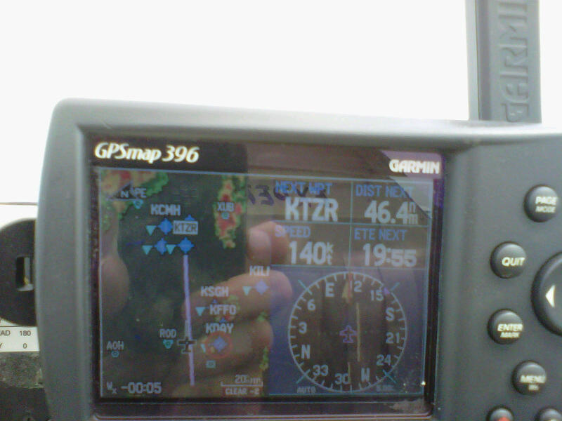
I wanted to get it back to him since the racing season is just about wrapped up. The weather looked flyable, although the forecast for high humidity and even higher temperatures led me to believe that the return flight in the afternoon would not be pretty, fun, or even passably comfortable. I left for the airport a little before 10am and was in the air shortly thereafter. I tuned (Heh! Quaint, archaic, and a bit ironic term there) the GPS to the Darke Co./Versailles (KVES) airport and what did I see? Yep, there was a big, fat storm cloud bearing down directly on my destination airport:

I was still plenty far away, and the beauty of the composite radar is that it shows a satellite's eye view of the storm. That allowed me to determine that it was a highly localized storm and would very likely blow over by the time I got there, assuming I had sense enough to slow down a little. After all, there's no sense in rushing into getting your tail kicked. I was also far enough away to plan an alternate destination. The paper map ("sectional chart" in pilot lingo) showed the airport near Celina to be far enough north to be out of the path of the store. I selected it as my new destination, and the radar confirmed that it would be a suitable place to wait out the rain if need be. I also slowed down a little.

The store was easily visible as I passed by to the north of it.

As I began my descent and approach into KCQA (Lakeview, I think), I could see the sky to south starting to clear up as the storm worked its way to the west. It seemed that I would be able to go direct to KVES without having to stop at KCQA. It wasn't until later in the day that I realized that I had aborted my approach into KCQA without announcing that I was going to do so on the CTAF frequency. They're probably still wondering where that guy "5 miles south, inbound for left downwind to runway 26" is. Note that I had also slowed down a bit more. I still wasn't in any big hurry to get down south.

By the time I reached the airport, the storm was off to the east and I was able to line up for a landing to the west.

I could still see the back end of the storm moving off to the west.

I took the opportunity to try out my new Oshkosh hat in less than clement conditions.

Later in the afternoon, the weather was still pretty spotty. Just north of Dayton it appeared that I would have clear (well, clear-ish, as it was still very hazy) sailing back to Columbus. The storm over XUB (Yellow Bud VOR, I think) was heading towards Rickenbacker and looked like it would miss Bolton. It did.
I checked the AOPA flight planner when I got back to the house. It looks like I timed it perfectly! My route is the diagonal black line near the middle of the picture.

It's a definite asset when you're using the plane to travel. I would have loved NEXRAD in the cockpit when we took our long flying trip two weeks ago. Of course, having to rely solely on Flight Service and ATC for non-Mark I eyeball weather avoidance was nice and nostalgic. Sirius-ly!
ReplyDelete